


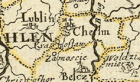
Pierwszy raz Zamość pokazany został na mapie Polski w 1613 (nie ma go na mapach Królestwa z wcześniejszych lat, m.in. z 1584, a także na słynnej mapie Piscatora z ...1639, a nawet na renomowanych mapach angielskich z 1662, 1676 i 1719!). Oprócz map ogólnych kraju, później taktycznych (do 1940) jest też mapa regionalna z 1826.
XVII w.
- Mapa z 1613 (Magni Ducatus Lithuaniae caeterarumque...), W. Blaeu, T. Makowski, Amsterdam, 1:1.300.000, 75x73 cm
- Mapa z 1634 (Polonia Regnum et Silesia Ducatus), W. Janszoon, Amsterdam, 1:1.400.000, 46x57 cm (istnieją egzemplarze tej mapy - Uniw. Wrocławski bez oznaczenia Zamościa! na innej mapie z tego i 1638 roku - M. Merian, Amsterdam - też nie oznaczono Zamościa)
- Mapa z 1648 (Le Royaume de Pologne), z wyd. Parallela Geographie Veteris..., Phillip Briet, Paryż, 16x20 cm;
- Mapa z 1652 (brak danych)
- Mapa z 1654 (Carte de Pologne et des Estats qui en dependent...), P. Duvall, Paryż, 1:2.700.000, 38x52 cm;
- Mapa z 1655 (Estats de La Couronne de Pologne...), S. d'Abbeville, Paryż, 1:2.800.000, 44x60 cm;
- Mapa z 16… (Les Royaumes du Nort … Les Estats de la Couronne de Pologne…), P. Du Val, Paryż, 19,5x25,4 cm;
- Mapa z 1659 przed (Regni Poloniae et Ducatus Lithuaniae…,), F. de Vit, Amsterdam, 49,5x55,5 cm;
- Mapa z 1661 (Pologne), Pierre Duval, Paryż, 11x13 cm;
- Mapa z 1666 (Haute ou Petite Pologne ou sont les Palatinats...), Nicolas Sanson, Paryż;
- Mapa z 1669 (A Mapp of the Estates of the Crowne of Poland, where...), R. Blome, Londyn, małoskalowa, 41x28 cm;
- Mapa z 1670 (Tabula nova totius Regni Poloniae...), Clement de Jonghe, Amsterdam, 43x56 cm;
- Mapa z 1670 (Polonia Regnum, w Historia di Leopoldo Cesare, continente...), Gaspar Bouttas, Antwerpia, 34x43 cm;
- Mapa z 1674 (La Russie Noire our Polonoise…) S. Sansons;
- Mapa z 1675 (Estats de Pologne subdivises suivant...), Guillame Sanson, Paryż, 1:1.900.000, 56x88 cm;
- Mapa z 1675 (Nova totius Regni Poloniae Mangique Ducatus....), J. Sandrat, Norymberga, małoskalowa;
- Mapa z 1678 (Stati della Corona di Polonia… w Mercurio Geographico),Giovanni de Rossi, Rzym, 43x57 cm;
- Mapa z 1678 Jacoba von Sandrata;
- Mapa z 1680 (Typus Generalis Ukrainae…), Johann Hoffmann, Norymberga -
- Mapa z 1680 (Magni Ducatus Lithuaniae Tabula...), F. de Wit, Amsterdam, 44x52 cm (najbardziej kuriozalna lokalizacja Zamościa, który oznaczony został jako siedziba biskupa katolickiego!)
- Mapa z 1683 (Estats de la Couronne de Pologne), Nicolas Sanson, Paryż, 19x25 cm
- Mapa z 1684 (Estats de Pologne subdivises suivant,... w Atlas Nouveau), Guillame Sanson, Hubert Jaillot, Paryż, 61,89 cm;
- Mapa z 1689 przed (Regni Poloniae et Ducatus Lithuaniae…), F. de Vit, Amsterdam, 48,5x56 cm;
- Mapa z 1689 przed (Regni Poloniae et Ducatus Lithuaniae… ), Jacopo de la Feuille, Amsterdam, 52,5x62 cm;
- Mapa z 1690 (Regni Poloniae et Ducatus Lithuaniae), Jacopo Le Feuille, Amsterdam, 1:2.600.000, 57x65 cm (też taka sama wyd. 1710);
- Mapa z 1692 (Les Estats de la Couronne de Pologne, subdivises...), A. Jaillot, Paryż, 1:3.000.000, 96x63 cm;
- Mapa z 1692 (Estats de Pologne subdivises suivant l'estendue des Palatinats), Guillaume Sanson, Alexis-Hubert Jaillot, Amsterdam, 57x87 cm;
- Mapa z 1696 (Estats de la Couronne de Pologne), Alexis-Hubert Jaillot, Amsterdam, 48x61 cm;
- Mapa z 1696 (Regni Poloniae Vicinarumque Regionum...), Erik Dahlberg, Norymberga, 29x37 cm;
- Mapa z 1697 (Regni Poloniae, Magni Ducatus Lithuaniae Coeterarumq...), C. Allard, Amsterdam, 1:2.600.000, 50x59;
- Mapa z 1697 (Le Royaume de Pologne), Jean Nicoloas de Tillemont, Jean Baptiste Nolin, Paryż, 47x59 cm;
i ta sama 1700 (Sedes Belli in Polonia et in Moscoviæ Turciæ ab...), C. Allard, Amsterdam, małoskalowa, 48x80 cm;
- Mapa z 1700 - ogólna (Compendiosa Poloniae repraesentatio), Joh. Stridbeck, Augspurg;
- Mapa z 1700 - prowincji (Compendiosa Poloniae repraesentatio), Joh. Stridbeck, Augspurg;
- Mapa rekonstr. z 1897 (Rzeczpospolita Polska wieku XVII). ułożył i rys. Jan Babirecki Litogr. K. Kranikowski, Kraków, 1:3.000.000, 50x43 cm;
XVIII w.
- Mapa z 1700 (Carte des estats de Suede de Dannemaro et de Pologne), N. de Fer, Paryż, 1:4.200.000, 35x43 cm;
- Mapa z 1700 (Reipublicae et Status Generalis Poloniae Nova Tabula...), Frederick de Wit, Amsterdam, 49x56 cm;
- Mapa z 1700 (Regni Poloniae et Ducatus Lithuaniae, Voliniae...), Danckaerts, Amsterdam, 1:2.300.000, 49x58 cm;
- Mapa z 1700 (Regni Poloniae et Ducatus Lithuaniae, Voliniae...), R&I. Ottens, Amsterdam, 50x58 cm;
- Mapa z 1700 (Estats de la Couronne de Pologne), Nicolas Sanson II, Amsterdam, 19x26 cm;
- Mapa z 1700 (Stati della Corona di Polonia…), Paolo Petrini, Neapol, 42x54 cm;
- Mapa z 1700 (Poland w Geography Rectified, Robert Morden, Londyn, 11x13 cm;
- Mapa z 1701 (Tabula nova totius Regni Poloniae...), wyd. Amsterdam, 1:3.200.000, 42x55 cm;
- Mapa z 1702 (La Pologne dresée sur ce qu’en ont donne Starovolsk, Beauplan, Hartknoch...), Guillaume de l’Isle, Paryż, 49x64 cm;
- Mapa z 1703 (La Pologne dresée sur ce qu’en ont donne Starovolsk, Beauplan, Hartknoch...), Guillaume de L`Isle, Paryż, 49x64 cm;
- Mapa z 1703 (Regni Poloniae Magni Ducatus Lithuaniae Reliquarumque...), P. Schenk, Amsterdam, 1:2.700.000, 58x50 cm;
- Mapa z 1703 (Les Estats de la Couronne de Pologne), Nicolas Sanson, Paryż, 20x25 cm;
- Mapa z 1705 (Estates des Couronnes de Dannemark, Suede et Pologne), Nicolas de Fer, Paryż, 44x70 cm;
- Mapa z 1705 (Les Estats de la Couronne de Pologne w Petit et nouveau atlas), Nicolas de Fer, Paryż, 14x20 cm;
- Mapa z 1705 (Hanc Regni Poloniarum Magnique Ducatus Lithvaniae…), Johann Baptist Homann, Norymberga, 50x57 cm;
- Mapa z 1706 (Le Royaume de Pologne avec ses confins w Atlas portatif, ou, le nouveau theatre de la...), Daniel de la Feuille, Amsterdam, 15x21 cm;
- Mapa z 1707 (Hanc Regni Poloniarum Magnique Ducatus Lithvaniae…), Johann Baptist Homann, Norymberga, 50x57 cm;
- Mapa z 1708 (Estats de la Couronne de Pologne subdivises suivant ... wyd. Atlas Francois), Guillame Sanson i Hubert Jaillot, Paryż, 47x65 cm;
- Mapa z 1708 (La Pologne dresée sur ce qu’en ont donne Starovolsk, Beauplan, Hartknoch...), Guillaume de l’Isle, Paryż, 49x64 cm;
- Mapa z 1710 (Regnum Poloniae divisum in Magnum Ducatum Lithuaniae…) Gerard i Leonard Valck, Amsterdam, 49x60 cm;
- Mapa z 1711 (Poland corrected from the observations...), John Senex, Londyn, 66x95 cm;
- Mapa z 1711 (Polon Lithuan Borus Pomer…), Petrus Schenk, Amsterdam, 49x58 cm;
- Mapa z 1711 (Estats de la Couronne de Pologne...), Pieter Mortier, Amsterdam, 48x61 cm;
- Mapa z 1711 (Estats de Pologne subdivises suivant l'estendue des Palatinats) z Atlas Nouveau), Guillaume Sanson Alexis-Hubert Jaillot, Amsterdam, 1711, 58x88 cm;
- Mapa z 1715 (Regni Poloniae Magnique Ducatus Lithuaniae…), Johann Baptist Homann, Norymberga, 49x56 cm;
- Mapa z 1717 (Estats de la Couronne de Polognede, wyd. L’atlas curieux), Nicolas de Fer, Paryż, 22x32 cm;
- Mapa z 1717 (Le Royaume de Pologne avec ses confins w Nouvelle méthode pour apprendre la géographie universelle), Daniel de la Feuille, Lyon, 16x21 cm;
- Mapa z 1718 (Poloniae & Lithvania… w Bequemer Schul- und Reisen Atlas), Johann Weigel&Johann Koehler, Norymberga, 28x35 cm;
- Mapa z 1718 (La Pologne dresee sur ce qu'en ont donne Starovolsk, Beauplan, Hartknoch...), Guillaume de l'Isle, Paryż, 49x64 cm;
- Mapa z 1719 (Poland) Rob. Morden, Londyn, 10x12,5 cm;
- Mapa z 1720 (Regni Poloniae Magnique Ducatus Lithuaniae Nova...), Sz. Starowolski, J. Homan, wyd. Norymberga, 1:2.800.000, 60x52 cm;
- Mapa z 1720 (Poland subdivided into its severall Palatinates...), Herman Moll, Londyn, 20x26 cm;
- Mapa z 1724 (Regni Poloniae Magnique Ducat, Lithuaniae Nova ...Starovolcii), J. Homann, Norymberga, 1:3.100.000, 48x56 cm;
- Mapa z 1724 (Regnum Poloniae ejusque confinia w Atlas Portatilis...), Johann Christoph Weigel, Norymberga, 14x18 cm
- Mapa z 1726 (Estats de la Couronne de Pologne), Alexis- Hubert Jaillot, Amsterdam, 51x61 cm;
- Mapa z 1728 (Poloniae Regnum ut et Magni Ducatus...), M. Seutter, Augsburg, 1:3:000.000, 50x57 cm (identyczne przedstawienia na wyd. z 1731, 1740 i 1770;
- Mapa z 1729 (Regni Poloniae Magnique Ducat, Lithuaniae Nova... Starovolcii), J. Homann, Norymberga, małoskalowa, 41x56 cm;
- Mapa z 1729 (Regni Poloniae Magnique Ducatus Lithuaniae), Johann B. Homann, Norymberga, 49x57 cm
- Mapa z 1730 (Tabula Regni Poloniae Ducatus Lithuaniae...), G. Del'Isle, Amsterdam, 49x62 cm;
- Mapa z 1730 (Estats de la Couronne de Pologne…), Pieter Mortier, Amsterdam, 48x60 cm;
- Mapa z 1730, br. danych;
- Mapa z 1732 (Le Royaume de Pologne), de Feille, Amsterdam, 14x17 cm;
- Mapa z 1734 (Nieuwe Kaart van t’ Koninkryk Poolen… w Nieuwe en Boknopte Hand – Atlas), Isaak Tirion, 29x35 cm;
- Mapa z 1734 (La Pologne dresee sur ce qu'en ont donne Starovolsk, Beauplan, Hartknoch...), Guillaume de L`Isle, Amsterdam, 49x63 cm;
- Mapa z 1735 (La Pologne w Nouvel Atlas), Pieter van der AA, Amsterdam, 23x30 cm;
- Mapa z 1735 (La Pologne et le Duche de Lithuania), wyd. Covens&Mortier, Amsterdam, 10x12 cm;
- Mapa z 1735 ok. (Le Pologne et de le Duche de Lithuanie) 12,5x14 cm;
- Mapa z 1736 (Les Etats De La Couronne De Pologne, sous les quels sont...), N. de Fer, Paryż, 1:4.200.000, 50x67 cm (też taka sama wyd. 1760);
- Mapa z 1739 (Regni Poloniae Magnique Ducatus Lithuaniae Nova...), Sz. Starowolski, wyd. Norymberga, 1:2.800.000, 48x54 cm;
- Mapa z 1740 (Geographische Vorstellung derer Königreiche Polen und Preussen… w Atlas curieux), Johann Stridbeck, Gabriel Bodenehr, Augsburg, 16x21 cm;
- Mapa z 1740 (La Pologne dresée sur ce qu’en ont donne Starovolsk, Beauplan, Hartknoch... w Atlas Noveau), Guillaume de L`Isle, Amsterdam, 49x62 cm;
- Mapa z 1745 (Le Royaume de Pologne le Grand Duche de Lithuanie), Georges Louis Le Rouge, Paryż , 51x65 cm;
- Mapa z 1747 (XXVI Haupt Karte Polen, wyd. Auxilia Historica, oder Historischer Behülff...), Anselm Desing, Stadt am Hof, 11x14 cm;
- Mapa z 1748 (Etats de la Courone de Pologne… z Atlas portatif, universel et militaire…), Gilles i Didier Robert de Vaugondy, Paryż, 17x22 cm;
- Mapa z 1748 (Pohlen, die Länge rechnet... w Der kuriose und in allen Wissenschaften nützliche Dolmetscher…), Elias Back, Augsburg, 16x22 cm;
- Mapa z 1749 (Reise Charte durch das Koenigreich Polen mit...), J. Schreiber, Lipsk, 1:9.300.000, 17x25 cm;
- Mapa z 1750 (Mappa geographica Regni Poloniae), Tobias Johann Mayer, Norymberga, 49x55 cm;
- Mapa z 1750 (Regno di Polonia divisio nei suoi palatinati), Giambatista Albrizzi, Wenecja, 30x36 cm;
- Mapa z 1750 (Regnum Poloniae divisum in Magnum Ducatum...), G. Valk, Amsterdam, małoskalowa, 49x59 cm;
- Mapa z 1752 (Le Royaume de Pologne, z Atlas Universel), Robert Didier Vaugondy, Paryż, 49x56 cm;
- Mapa z 1753 (Tabula Geographica Regni Poloniae…), Leonhard Euler, Berlin, 32x38 cm;
- Mapa z 1753 (Polonia Seraphico - observans, juxta Domicilia propriae et alienae jurisdictionis...), wyd. nn, małoskalowa, 50x60 cm (wg BN 1760, mapa dot. zakonów);
- Mapa z 1754 (Estates de la Couronne de Pologne), Nicolas de Fer, Paryż, 22x32 cm;
- Mapa z 1754 (Estats de la Couronne de Pologne), Paryż;
- Mapa z 1756 ok. (Map of the Several Countries…), Londyn, 23x18 cm;
- Mapa z 1756 (Polonia Seraphico Observans juxta Domicilla…), Tobiasz Lotter;
- Mapa z 1757 (Les Royaumes de Pologne et de Prusse),Tobias Johann Mayer, Paryż, 43x54 cm;
- Mapa z 1759 (Mappa geographica ex novissimis observationibus repraesentans Regnum Poloniae…), Tobias Conrad Lotter, Augsburg, 49x58 cm;
- Mapa z 1760 (Les Royaumes de Pologne et de Prusse), Jean Janvier, Paryż, 48x66 cm;
- Mapa z 1762 (Carte Generale de la Pologne...), M. Rizzi Zannoni, Paryż, 31x45 cm;
- Mapa z 1765 (Royaume de Pologne, Duche de Lithuanie…, wyd. Atlas elementaire de la geographie), Pierre Bourgoin, Paryż, 37x45 cm;
- Mapa z 1766 (A new and accurate map of Poland, Lithuaniae... wyd. Uniwersal History of the World), Emanuel Bowen, Londyn, 25x43 cm;
- Mapa z 1768 (Gross und Klein Polen in seine Woiewodschaften...) wyd. Lipsk, małoskalowa (na mapie Zamość oznaczony graficznie jako miasto, natomiast jako twierdze - Bełz, Chełm, Lublin, Sandomierz!);
- Mapa z 1769 (Royaume de Pologne w Géographie moderne avec une introduction), Louis Baptiste Jean L'Abbe Clouet, Paryż, 32x56 cm;
- Mapa z 1769 (Karta priedstawliajuszczaja Polszu i Mołdawiu s około lieżaszczimi Ziemliami), I. Trusccott, 81x124 cm;
- Mapa z 1770 (Nova Mappa geographica Regni Poloniae, Magni Ducatus Lituaniae..., ark. 3), G. Friedrich, Norymberga, 1.700.000, 44x52 cm;
- Mapa z 1770 (Regni Poloniae Magni Ducatus Lituaniae Nova Mappa Geographica..., arkusz I), 1:675 000, T. von Pfau, Berlin, 48x55 cm;
- Mapa z 1771 (Mappa Geographica Regni Poloniae...), Anton Friedrich Büsching, Florencja, 46x 53 cm;
- Mapa z 1772 (Carte de la Pologne divisée par provinces et palatinats... atlas, karta: Wojewodztwa Lubelskie...), wyd. Rizzi, Zannoni, Paryż, 1:692.000, 53x33 cm;
- Mapa z 1772 (Tabula Poloniae et Lithuaniae geographica minor), Christian Benjamin Glassbach, Berlin, 50x55 cm;
- Mapa z 1772 (Das ehemalige Königreich Polen nach den grenzen von 1772 mit...), C. Wolff, Hamburg (wyd. 1872), 1:3.000.000, 49x59 cm;
- Mapa z 1772 (Le Royaume de Pologne), Robert Didier Vaugondy, Paryż, 50x62 cm;
- Mapa z 1772 (Le Royaume de Pologne…), Jean Nicoloas de Tillemont, Jean B. Nolin, Paryż, 47x59 cm;
- Mapa z 1772 (Map of Moscovy, Poland, Little Tartary and y Black Sea…) Herman Moll, Londyn, 61x99 cm;
- Mapa z 1772 (Carte Generale de la Pologne avec tous les Etats…), Giovanni Antonio Rizzi-Zannoni, Paryż, 33x46 cm
- Mapa z 1772 (Mappa Polski z panowania Stanisława Augusta w 1772, oprac. 1849), Z. Steinbrich, Warszawa, 1:2.700.000, 47x61 cm;
- Mapa po 1772 (Accuratissima Regni Poloniae Nova Tabula Comirehendens Maioris et Minoris…), August, Reinier i Ottens, Amsterdam, 51x88 cm;
- Mapa z 1773 (Carte Generale et itineraire de la Pologne), K. Perthes, Warszawa, 1:5.000.000, 32x34 cm cm;
- Mapa z 1773 (Geographica Regni Poloniae, Tobias Johann Mayer, Norymberga, 48 x 54 cm;
- Mapa z 1773 (Poland shewing the claims of Austria, Russia and Prussia, wyd. A new system of geography), Thomas Sen Kitchin Londyn, 19x29 cm
- Mapa z 1775 (Poland, wyd. Atlas methodique), John Lodge, Paryż, 44,5 x 53,3 cm;
- Mapa z 1775 (Bowle's new pocket map of the Kingdom of Poland and Grand Dutchy of Lithuania w Bowles universal atlas), Henry Carington Bowles, Londyn, 47x55 cm;
- Mapa z 1775 (Carte curieuse des nouvelles limites de la Pologne), Louis Brion de la Tour, Paryż, 37x42 cm;
- Mapa z 1775 (Mappa geographica ex novissimis observationibus repraesentans Regnum Poloniae…), Tobias Conrad Lotter, Augsburg, 49x59 cm;
- Mapa z 1775 (Polen Litauen und Kurland), D.F.Sotzman, Berlin1:2.600.000, 44x50 cm;
- Mapa z 1775 (Lubomeriae et Galliciae Regni), Norymberga, 44x55 cm;
- Mapa Miega z 1779-1782;
- Mapa z 1780 (Les Royaumes de Pologne et de Prusse), Jean Janvier, Paryż, 48x65 cm;
- Mapa z 1780 (Mappa Geographica ex novissimis ebservationibus repraesentans Regnum Poloniae…) Tobias Conradi Lotter, w Atlas geographicus, Norymberga, 1:2.500.000, 58x48 cm;
- Mapa z 1780 ok. (Carte nouvelle des Royaumes de Galizie), Tobias Lotter, Augsburg, 49x54 cm;
- Mapa z 1780 (La Pologne dresee sur ce qu'en ont donne Starovolsk, Beauplan, Hartknoch...), Guillaume de L`Isle, Paryż, 49x64 cm;
- Mapa z 1782 (La Polonia divisa... wyd. Atlante novissimo, illustrato...), Antonio Zatta , Antonio Rizzi-Zannoni, Wenecja, 32x42 cm;
- Mapa z 1782 (Poland shewing the Claims of Austria, Russia & Prussia), John Carry, Londyn, 20x30 cm;
- Mapa z 1782 (Les Etats de la Couronne de Pologne w „Atlas general contenant le detail…”, Nicolas de Fer, Paryż, 47x59 cm,
- Mapa z 1783 (Etats de la Couronne de Pologne), Jean-Baptiste Nolin, Paryż, 22x28 cm;
- Mapa z 1783 (Present Poland Prussia &...)Samuel John Neele, Londyn, 38x41 cm;
- Mapa z 1783 (Present Poland Prussia &..") w: "Universal Atlas by Stackhouse", oznacz. k. XVIII w., Samuel John Neele, Londyn, 38x41 cm
- Mapa z 1786 (Carte de la Pologne avec ses Démembremens), Thomas Sen Kitchin, Genewa, 40x50 cm;
- Mapa z 1786 (Dritter Theil der Karte von Europa welcher das südliche Russland Polen und Ungarn), Jean-Baptiste Anville, Franz Anton Schrämbl, Wiedeń, 64x87 cm;
- Mapa z 1787 (Royaumes de Pologne et de Prusse, wyd. Petit Atlas Moderne), Jean Lattre, Paryż, 20x27 cm;
- Mapa z 1787 (A new map of the Kingdom of Poland w A general atlas describing the whole universe), Robert Sayer, Londyn, 49x66 cm;
- Mapa z 1787 (Carte de la Prusse, de la Grande et Petite Pologne… w Universelle depuis le commencement du monde…), Louis Brion de la Tour, Paryż, 23x26 cm;
- Mapa austriacka z 1788 (Generalkarte von Polen, Litauen, und den angraenzenden...), wyd. Wiedeń, 1:1.300.000, 85x98 cm (kolejne wydanie z 1793, z tą samą, pomieszaną lokalizacją okolicznych miejscowości, m.in. Zamościa i Nowego Zamościa);
- Mapa z 1788 (Nova Mappa Geographica Regni Poloniae), Georg Friederich, Norymberga, 91x107 cm (w 16 częściach);
- Mapa z 1789 (Triplice Ripartimento della Polonia fatto nel 1772), Antonio Zatta,Wenecja, 51x67 cm;
- Mapa z 1789 (Cio che fù e cio che è al presente la Polonia), Bartolomeo Borghi, Carli Pazzini, Siena, 23x32 cm;
- Mapa z 1790 (Poland Lithuania and Prussia from... w Grammar and present state of the several Kingdoms of the World), William Guthry, Thomas Kitchin, Londyn;
- Mapa z 1790 (Etats de Pologne et de Lithuanie, z Atlas Historique...), Louis Brion de la Tour, Paryż, 28x32 cm;
- Mapa z 1791 (A Map of Poland with its Dismembered Provinces w The habitable world described...), Samuel John Neele, Londyn, 18x19 cm
- Mapa austriacka z 1791 (Des Koenigreichs Galizien und Lodomerien...), F. Reilly, Wiedeń, 1:1.300.000, 22x29 cm;
- Mapa z 1791 (General Karte von der königlichen Republik Polen), Franz Johann Josef von Reilly, Wiedeń 22x33 cm;
- Mapa z 1792 (La Pologne Divisee en Royaume de Pologne et les etats...), Jan B. Elwe, małoskalowa, Amsterdam, 49x61 cm;
- Mapa z 1793 (Charte des Königreichs Polen), Ludwig Franz Güssefeld, Weimar, 52x59 cm;
- Mapa z 1794 (Poland with its dismembred provinces, drawn from... z A general atlas being a collection of maps of the world…), Thomas Conder, Londyn, 22x28 cm;
- Mapa z 1794 (A new map of the Kingdom of Poland w A new universal atlas), Robert Sayer, Londyn, 49x67 cm;
- Mapa z 1794 (A new map of the Kingdom of Poland…, z A New Atlas of the Mundane System...), Samuel Dunn, Londyn, 33x46 cm;
- Mapa z 1795 (Mappa geographica Poloniae), Tobias Johann Mayer, Norymberga, 45x52 cm;
- Mapa z 1795 (Charte von Polen Preussen u. Galicien w Kleiner Atlas nach den neuesten..), Johann Georg Probst, Augsburg, 17x27 cm;
- Mapa z 1795 (Bowle's new one-sheet map of Poland and Prussia w Bowles’s Universal Atlas), Henry Carington Bowles, Londyn, 48x55 cm;
- Mapa z 1795 (Royaume de Pologne), Robert Didier Vaugondy, Paryż, 25x29 cm;
- Mapa z 1796 (Polen nach seiner ersten and letzten, oder gaenzlichen Theilung), Johann Walch, Augsburg, 47x58 cm;
- Mapa z 1796 (Polen nach seiner ersten, und letzten, oder gänzlichen Theilung), Johann Georg Probst, Augsburg, 49x58 cm,
- Mapa z 1796 (A new & accurate map of Poland with its dismemberd Provinces wyd, General Atlas) Samuel John Neele, Edynburg, 29x34 cm;
- Mapa z 1796 (Poland Shewing the Claims of Russia, Prussia & Austria from... w New geographical, historical and commercial grammar), William Guthry, Londyn, 19x23 cm;
- Mapa z 1796 (Polen Litauen und Kurland), Berlin, 44x51 cm;
- Mapa z 1796 (Karte von Polen), Franz Johann Josef von Reilly, Wiedeń, 62x76 cm;
- Mapa z 1796 (Karte von Polen nach dem Petersburger Theilungstraktate), Franz Johann Josef von Reilly, Wiedeń 63x76 cm;
- Mapa z 1798 (Carte generale de la Pologne, w Atlas Moderne Portatif), Citoyen Berthelon, Paryż, 18x21 cm;
- Mapa z 1798 (Poland with its dismembered provinces, including Prussia w Universal atlas by Stackhouse), Samuel John Neele, 38x41 cm;
- Mapa z 1799 (A Map of the Kingdom of Poland and Grand Dutchy…), Londyn, 1:2.400.000, 54x59 cm;
- Mapa z 1799 (A map of the Kingdom of Poland and Grand Dutchy... w General Atlas), William Faden, Londyn, 55x63 cm;
- Mapa z 1799 (Il Regno di Polonia con i smembramenti), Antonio i Giacomo Zatta, Wenecja, 21x23 cm;
- Mapa z 1799 (La Polonia), Antonio Zattaso, Wenecja, 17x22 cm;
XIX w.
- Mapa z 1800 (Polens Ende durch die letzten Theilungen und Besitznehmungen...), K. Hübner, Lipsk, małoskalowa, 59x52 cm;
- Mapa z 1801 (Poland z Atlas Universel), John Cooke, Londyn, 14x14 cm;
- Mapa francuska z 1802 (La Pologne avec les Partages, z Atlas Universel pour la geographie de Guthrie” Alexandre Blondeau, Paryż, 20x24 cm;
- Mapa z 1802 (La Pologne divisee en ses palatinats selon la derniere…), Antonio Zatta, Wenecja, 50x67 cm;
- Mapa austriacka z 1803 (Ost Galizien Zweites Blatt… Zamoscer … Kreis,..) Joseph Kindermann, Kipferling, Liesganig, Wieden 1803, też Galizie orientale, de zamosk, , 1:537 000, 48x58, dwie różniące się wersje;
- Mapa z 1804 (Carte Générale de la Pologne…, Giovanni Antonio Rizzi-Zannoni, Paryż, 33x46 cm;
- Mapa z 1806 (Carta geologica totius Poloniae, Moldaviae... per Staszic), Warszawa, 1:1,800.000, 50x67 cm;
- Mapa z 1806 (Charte von Polen), Ludwig Franz Güssefeld, Weimar, 46x52 cm;
- Mapa z 1807 (Polen nach sejner ersten, und letzten, oder...), Johann Walch, Augsburg, 47x 58 cm
- Mapa z 1807 (Polen in die dermaligen Besitzungen…), Franz A. Schrämbl, Wiedeń, 87x103 cm (16 części)
- Mapa z 1807 (Charte von Polen), Ludwig Franz Güssefeld, Weimar, 52x58 cm;
- Mapa z 1807 (Carte Generale et Itineraire de la Pologne…), Jan van Jagen, Amsterdam, 51x54 cm;
- Mapa pruska z 1807 (Charte von Polen nach dem Frieden zu Tilsit...), wyd. Weimar 1810, małoskalowa;
- Mapa z 1807 (Poland Shewing the Claims of Russia, Prussia and Austria from the best..., James Barlow, Suffolk, 18x21 cm;
- Mapa austriacka z 1808 (Carte von West-Galizien... von Hieronimus Benedicti), wyd. Wiedeń, 1:172.000, 50x44 cm;
- Mapa z 1810 (Charte von Koenigreich Preussen nebsst dem Herzogthum Warschau,), Ludwig Franz Güssefeld, Norymberga;
- Mapa z 1811 (Generalkarte von Königreich Preussen...), Friedrich Daniel Sotzmann, Norymberga, 58x67 cm
- Mapa pruska z 1812 (Schauplatz des Französisch-Russischen Krieges...), wyd. Berlin, małoskalowa; Zamość zaznaczony jako "duże miasto" (!), a nie twierdza, jak Chocim, czy Kamieniec);
- Mapa amerykańska z 1814 (Poland, wyd. General Atlas), Matthew Carey, Filadelfia, 32x37 cm;
- Mapa "pruska" z 1811-1815 (Topographisch-militärische Charte von dem Konigreichen Preussen und Polen...), wyd. Weimar, 1:180.000, 45x35 cm, unikalny egz. w zbiorach AP w Zamościu;
- Mapa z 1812 (Poland z New Universal Atlas), John Cary, Londyn, 23x28 cm;
- Mapa z 1812 (Mapa Księstwa Warszawskiego), w zb. APL;
- Mapa francuska z 1816 (Poland as Divided z World Atlas), John Thomson, J. i G. Menzies, Edynburg, 45x50 cm;
- Mapa z 1817 (Come fu e come trovasi divisa al presente la Polonia w „Atlante geografico”, Bartolomeo Borghi, Florencja, 23x32 cm;
- Mapa z 1817 (Nouveau Royaume de Pologne), De Robert Didier Vaugondy, Paryż, 50x63 cm;
- Mapa z 1817 (Mapa pocztowa i podróżna Królestwa Polskiego...), Wilhelm Sander; 1:1.140.000, 76x61 cmw zb. UMK Toruń;
- Mapa z 1820 (La Polonia colle divisioni, Giuseppe Caniani, Mediolan 19x23 cm;
- Mapa austriacka z 1824 (Koenigreich Galizien-Lodomerien...1790) J. Liesganig, Wiedeń, 1:288.000, 62x47 cm;
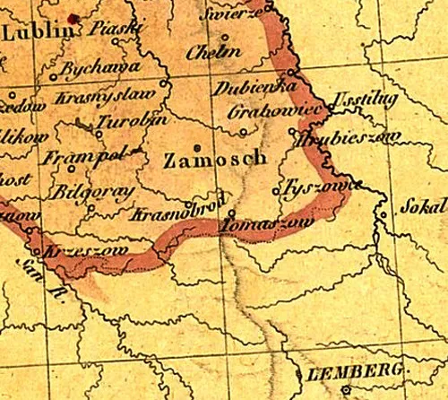
- Mapa z 1826 (Mappa jeneralna Wojewodztwa lubelskiego...), J. Colberg, Warszawa, 1:530.000, 43x57 cm;
- Mapa z 1827 (Mappa Polski i krajów okolicznych ze szczególnym wskazaniem... Atlas), J. Stawiński, Warszawa, małoskalowa, 52x38 cm;
- mapa z 1828 (Karta Królestwa Polskiego obeymująca wszystkie miasta…), J. Kośmiński, Warszawa, 1:1050.000, 55x45 cm;
- Mapa z 1831 (Teatr woyny narodowey w roku 1831), wyd. Paryż, 1:1.800.000, 54x52 cm;
- Mapa niemiecka z 1831 (Das Alte und Neue Polen...), E. Michaelis, Monachium, 1:4.000.000, 38x31 cm;
- Mapa francuska z 1831 (Carte des ètats de Pologne et du Grand Duché de Lithuanie…), Eustache Herisson, Paryż, 46x64 cm;
- Mapa z 1836 (Geognostysche General Karte von den Koenigreich Polen und Gallizien...), G. Pusch, Sztuttgart, Tybinga;
- Mapa kwatermistrzostwa z 1839 (CP-50, kol. VI, sek XI), w zb. AGAD, repr. dokumentacja WKZ;
- Mapa z 1840 (Carte Générale routiere historique et statistique des etats…), Leonard Chodźko, Paryż, 47x58 cm;
- Mapa kwatermistrzostwa z 1843 (Topograficzna karta Królestwa Polskiego - jeden z 59 wycinków), 1:126.000;
- Mapa angielska 1843 (A Map of the Kingdom of Poland, describing... wyd. A New General Atlas of Modern Geography), Wiliam Faden, Londyn, 55x62 cm;
- Mapa niemiecka po 1846, Reymanna (arkusz 154.D.), wyd. Głogów, 1:200.000, 34x23 cm;
- Mapa z 1849 (Das Koenigigreich Galizien), C.F. Weiland, Weimar, 1:1.110.000, 44x60 cm;
- Mapa polska z 1859 Chrzanowskiego z 1859 (Karta dawnej Polski z przyległymi okolicami..., W. Chrzanowski, k. 33), wyd. Paryż, 1:300.000, 49x50 cm;
- Mapa z 1867 (Mappa Królestwa Polskiego podług nowego podziału…), L. Herkner, Warszawa, 1:1.800.000, 38x29 cm
- Mapa z 1867 (Karta Carstwa Polskago), wyd Ilina, Petersburg, 1:840.000;
- Mapa z k. XIX w. (Dorożnaja Karta Liublinskoj Guberni), A Mancer ;
XX w.
- Mapa z 1904 - Epoka przełomu z wieku XVI-go na XVII-ty. Ziemie ruskie Rzeczpospolitej, w: atlasie Źródłowe dzieje Polska XVI-go A. Jabłonowskiiegp. Paryż;
Mapa rosyjska z 1907
- Mapa austriacka z 1909, też 1914 kolor. (Spezialkarte der österreichisch-ungarischen Monarchie, Zone 3 Col. XXVIII, Zamość) 1:75.000, 38x47 cm;
- Mapa austriacka z 1910 (Generalkarte Oesterreichischen Monarchie);
- Mapa austriacka z 1914;
- Mapa z 1915 Mapa Królestwa Polskiego J.M. Bazewicza, Warszawa, 1:000.000, 66x47 cm;
- Mapa niemiecka z 1915 (Gruppe Breßt Litowßk - pomniejszona mapa ros.), 1:25.000, 49x44 cm; w zb. AP Zamościu;
- Mapa niemiecka z 1915 (Karte des westlischen Russlands), 1:100.000, 39x35 cm, w zb. AP w Zamościu;
- Mapa rosyjska z 1916 (ark. XXIX-14), 1:84.000;
- Mapa austriacka z 1917 (Spezialkarte der österreichisch-ungarischen Monarchie" - Zone 3 Col. XXVIII, Zamość) 1:75.000, 38x47 cm;
- Mapa austriacka z 1918 (KuK200K41-51 Generalkarte von Mitteleuropa, Wien), 1:200.000; różne wydania;
- Mapa z 1922 (Rzeczpospolita Polska i kraje ościenne), WIG, Warszawa, 1:1.500.000, 76x72 cm;
- Mapa WIG z 1932, 1:300.000;
- Mapa WIG z 1936, 1:100.000, 39x35 cm, w zb. AP w Zamościu;
- Mapa niemiecka z 1940 (Sonderausgabe ehem. Polen - niemieckie powiększenie WIG), 1:25 000.
- Mapa amerykańska z 1943 (Poland. The map was created for use by War and Navy Department agencies during World War II, Princeton, 1:100.000

MAPY POLSKI I ZAMOŚĆ
- Szczegóły
- Nadrzędna kategoria: M
- Kategoria: MAN-MAZ
- Odsłon: 4538
- Galeria:


© 2024 Andrzej Kędziora
Treści Zamościopedi.pl udostępniane na stronach innych serwisów muszą być opatrzone znakiem
"Copyright. Wszystkie prawa zastrzeżone"